

The Virginia Department of Transportation is holding to provide information to the public and gather feedback regarding the Craig-Botetourt Scenic Trail.
VDOT will hold one meeting from 4 to 6 p.m. Tuesday at Eagle Rock Elementary School in Botetourt County, and another from 4 to 6 p.m. Wednesday at Craig County High School.

will run between Last Lock Park near Eagle Rock and Craig County High School in New Castle. It will follow the former Chesapeake and Ohio Craig Valley Branch railbed and right of way, which was donated to Virginia in 1961 for ŌĆ£for such public use as Commonwealth may determine,ŌĆØ according to VDOT.
People are also reading…

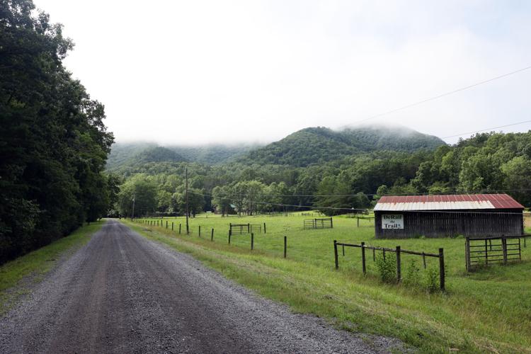
A ŌĆśDeRail the TrailŌĆÖ sign is seen on a homeownerŌĆÖs property Friday facing a section of what will be part of the Craig-Botetourt Scenic Trail on Old Rail Road in Eagle Rock. Some property owners along the trail have raised concerns about the 26-mile project.
In September 2023, the General Assembly put funds toward five multi-use trail projects across Virginia, one of which being the Craig-Botetourt trail. That same month, VDOT held informational meetings about the trail in both counties.
The Commonwealth Transportation Board has allocated $19.5 million for the trail, which VDOT anticipates will be enough to construct around 20 miles, from Craig County High School to the end of state maintenance on Craig Valley Drive.
Some adjacent property owners have deep concerns about the trail, and they generally differ by what county theyŌĆÖre in. In Craig County, where sections of the trail go through neighborhoods and pass by private property, some are worried about having a public trail so close to their homes.

Signs opposing the Craig-Botetourt Scenic Trail are seen in the town of Oriskany where many area residents have concerns about safety where the trail is shared by cars, hikers, bikers and horseback riders.
ŌĆ£I have some friends and neighbors that were somewhat blindsided by this project,ŌĆØ said Woody Lipps, chairman of Craig CountyŌĆÖs citizen committee for the trail. ŌĆ£This state-owned property puts this trail fairly close to their residences, and IŌĆÖm sensitive to that.ŌĆØ
Both counties have citizen committees to help with planning and coordination with VDOT. Lipps said the committee heŌĆÖs on was formed to listen to property ownersŌĆÖ concerns about the trail and work with VDOT on mitigations to address them.
To Lipps, the trail represents an opportunity for economic development and positive change in Craig County. It will allow both counties to actively promote their communities as what they want them to be and to share some of their ŌĆ£natural beauty, peace and quiet, and outdoor experience,ŌĆØ he said.
ŌĆ£This trail represents a change, and to some, particularly those who live next to it, a profound change,ŌĆØ he said. ŌĆ£I understand their feelings. I empathize with their emotions.ŌĆØ
ŌĆ£In the natural world, thereŌĆÖs only two directions, plant or animal ŌĆ” The two directions are youŌĆÖre growing, or youŌĆÖre dying. Nothing stays the same,ŌĆØ he added.
Around 9 miles of the trail corridor is located on VDOT-maintained secondary roads. Most of these ŌĆ£share the roadŌĆØ sections, which cars, hikers, bikers and horseback riders will all use, are located in Oriskany. Residents who live in the area and are opposed to the trail, like Jim Stadtlander, are primarily concerned with safety. Stadtlander is a founding member of , a group oppositing the project.
ŌĆ£WeŌĆÖve already come across scenarios where kids are scattered all over the road on their bicycles with mom, trying to bring a dog with them,ŌĆØ he said. ŌĆ£SheŌĆÖs more worried about the dog, and all the sudden thereŌĆÖs a car coming down the road.ŌĆØ

Jim Stadtlander, coordinator for DeRail the Trail, stands near a suspended pedestrian bridge that parallels Virginia 817 near where a proposed new hiking, biking and horseback-riding trail would follow Craig Creek between New Castle and Eagle Rock.
At nearly 4 miles, Old Rail Road is the longest ŌĆ£share the roadŌĆØ portion of the trail. Like many roads of its kind, biking and horseback riding are already permitted uses on Old Rail Road. However, Stadtlander is worried that labelling the route as a trail may lead to increased use of it as such, and that people using the trail may not realize itŌĆÖs also a road for vehicles.
ŌĆ£Calling it a trail leads to a lot of confusion as to those who are using it,ŌĆØ he said. ŌĆ£They will be coming off of sections that are trails, and then they get onto a road.ŌĆØ
Old Rail Road is a narrow gravel road with a one-way bridge and few places to pull over. The road isnŌĆÖt wide enough to , he said. There are no plans to pave or widen the secondary roads, according to VDOT. The road is considered low-volume, as VDOT determined it carries around 40 vehicle trips per day.

A bridge, wide enough for one vehicle at a time, spans Craig Creek on Old Rail Road, which will be incorporated into the 26-mile Craig-Botetourt Scenic Trail.
Oriskany sits almost directly on the trailŌĆÖs halfway point, and thus was deemed an ideal place for a trailhead. Pathfinders for Greenways, a nonprofit formed in 1997 to involve citizens in greenway development, recently closed on 15 acres on Old Rail Road, intending to give the land to VDOT for a trailhead, said Liz Belcher, former ┬ķ╗©╩ėŲĄ Valley greenway coordinator and current Pathfinders board member.
This new trailhead will be located across from the Craig Creek Recreation Area entrance and will include space for 10 trucks with horse trailers and 14 passenger vehicles, according to VDOT. A private land owner offered to sell them the land after the public meetings in 2023.
Pathfinders applied to and received a Preservation Trust Fund grant from the Virginia Outdoors Foundation, Belcher said. The foundation will reimburse Pathfinders $200,000 for the land purchase, she added, so long as the deed to the property specifies that it will always be open space.
From that trailhead, people will be able to access around 100 miles of trails between the U.S. Forest Service trails and the Craig-Botetourt trail, Belcher said.
In addition to the trailhead, she added, Pathfinders has supported the Craig-Botetourt Scenic Trail project through more than .
Some folks in Oriskany are also worried about a section of the trail that they have previously used as an ŌĆ£emergency routeŌĆØ in cases of extreme flooding. VDOT has stated that residents will still be allowed to use this route during high-water events, but some are concerned about VDOT putting a locked gate on the road.
ŌĆ£This area gets completely cut off from getting out to the rest of the world,ŌĆØ Stadtlander said.
Jason Bond, a spokesperson for VDOT, said that the current plan is to gate the road, as it is not a designated secondary road and not meant for everyday use. VDOT is ŌĆ£considering options for how to manage accessŌĆØ to the road during high-water events, he said.
VDOT also plans to construct trailheads in Charlton and Parr. The parking at Craig County High School will be eliminated once the project is done. Six bridges along the former railbed will be modified, two box culverts will be rehabilitated and two box culverts will be replaced, according to VDOT.
Crews are currently working along the trail corridor; however, VDOT says this is maintenance and not trail construction.
ŌĆ£VDOT has been clearing brush and stabilizing the former railbed to enhance access for designers as they continue to develop construction plans,ŌĆØ the agency says. ŌĆ£These activities are not a part of the trail construction project but will prevent additional deterioration of the former railbed.ŌĆØ
Photos: Along the route of the Craig-Botetourt Scenic Trail
Signs opposing the Craig-Botetourt Scenic Trail are seen in the town of Oriskany where many area residents have concerns about safety where the trail is shared by cars, hikers, bikers and horseback riders.
A bridge, wide enough for one vehicle at a time, spans Craig Creek on Old Rail Road, which will be incorporated into the 26-mile Craig-Botetourt Scenic Trail.

A 'DeRail the Trail' sign is seen at Jim Stadtlander's home on Friday facing Old Rail Road in Botetourt County where a part of the Craig-Botetourt Scenic Trail will pass by. Property owners have raised concerns about the 26-mile project.

Craig County High School can be seen at the beginning of the 26-mile Craig-Botetourt Scenic Trail project.

The Oriskany Post Office is is located on Oriskany Square. The area residents of the small town have safety concerns about the Craig-Botetourt Scenic Trail project.

A fawn crosses Old Rail Road in Eagle Rock where a section of the Craig-Botetourt Scenic Trail will be.

A map┬Āshowing the route of the proposed Craig Botetourt Scenic Trail between New Castle and Eagle Rock following an old railbed along Craig Creek.

A one-lane bridge on Virginia 817, also known as Old Rail Road, in Oriskany. Hikers, bikers, horseback riders and motorists will share this bridge as a part of the Craig-Botetourt Scenic Trail route.
Jim Stadtlander, coordinator for DeRail the Trail, stands near a suspended pedestrian bridge that parallels Virginia 817 near where a proposed new hiking, biking and horseback-riding trail would follow Craig Creek between New Castle and Eagle Rock.
A ŌĆśDeRail the TrailŌĆÖ sign is seen on a homeownerŌĆÖs property Friday facing a section of what will be part of the Craig-Botetourt Scenic Trail on Old Rail Road in Eagle Rock. Some property owners along the trail have raised concerns about the 26-mile project.


